Hello World,
I am very happy
to learn that India has initiated the implementation of a dedicated
navigational system of satellites to enable civilians and military
establishments with navigation in and around India. IRNSS, as the Indian space
program calls it, is a regional navigational system, meaning it would only
cover India and surrounding regions. This system is quite different from the
global navigational systems that are capable of locating any point on planet
earth. Having sat through the orbital mechanics, attitude dynamics, space
propulsion and spacecraft design classes at Mississippi State University, I am
more than eager to analyze the IRNSS based on what I’ve learned and make an
attempt to look into the possible opportunities that the IRNSS may provide along
with the challenges it may face. Click here to download the PDF version of this post.
The first of the
7 satellites of IRNSS, namely the IRNSS-1A was launched on July 1st,
2013. According to the official releases, the satellites are supposed to be
lined along 34o, 55o, 83o, 111.5o
and 131.5o East longitudes. 4 of the7 satellites would be in
geosynchronous orbits while the remaining three would be geostationary. The
inclination for the geosynchronous orbits as per official release is 29o.
Base on the basic information we have so far, it becomes easy to draft the
ground track of the IRNSS satellites with a little wiggle room for satellite
positioning that we would be discussing further in this article. Given below is
Fig.1 which is my conception of how IRNSS would be (This is a Ground Track or
2D plot of Path traced by the satellites as per the information given above,
simulated using STK):

Fig 1 Indian Regional Navigation Satellite System Schematic
(Conceptual)
Fig.1 given
above has 3 satellites along the equator and 4 satellites located at either end
of the 8-shaped loop. The 3 satellites (titled GEO-#) without a visible
trajectory-plot are Geo-stationary satellites that are supposed to be above a
specific location on earth at all times. In other words, they tend to revolve
around the earth in a heavily synchronized manner that for the observer on
earth, these satellites are just stationary objects in the sky. Therefore the
2D-Plot above has no visible path traced on the map. The other 4 satellites
(titled GSO-#) are geosynchronous satellites that are in orbits inclined with
the earth’s equator. The extent of the 8-shaped loop on either side of the
equator indicates the inclination of the geosynchronous orbit. As per official
release, the inclination of the geosynchronous satellite orbits is 29o
and you can see that the 8-shaped loop extends until 29 degrees on either side
of the equator. This orbit has a trajectory traced on the map, making the
geosynchronous satellites visible over a “specific region” on earth. The
position of the geosynchronous satellites, at either ends of the 8-shaped
trajectory are a result of a basic assumption and in reality, their position
with respect to their complimentary geosynchronous satellites may be different
depending upon the orbital design which in turn would depend on the IRNSS
strategic requirements that we will discuss as we proceed further.
Orbit Altitudes and Impacts
The IRNSS
satellites are, based on the minimal details we have so far, are designated
into orbits that are rather located at very high altitudes. The IRNSS-1A
satellite has been launched into an orbit with an apogee of 35874.6 km, which
is around the standard GSO/GEO orbit parameters (altitude wise). This altitude
also marks the end of Middle Earth Orbits (MEO) and the beginning of High Earth
Orbits (HEO). The GPS satellites are located at an altitude of approximately
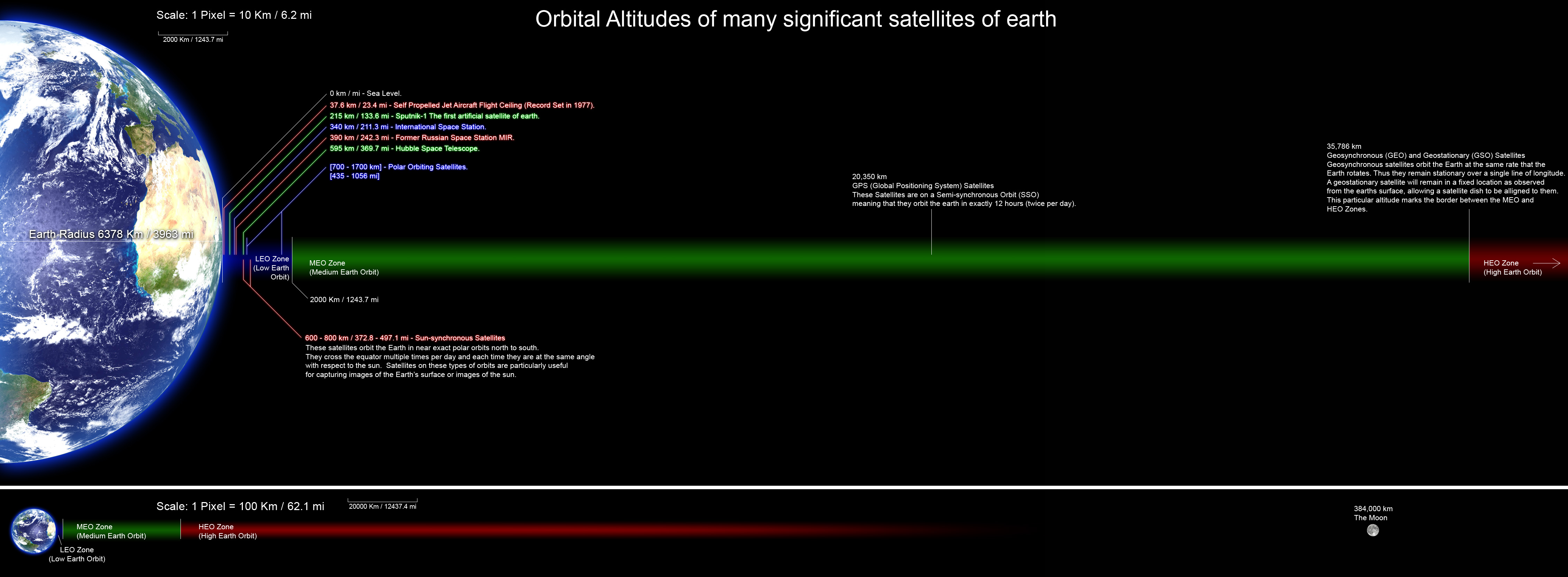
20000 km, which is in the mid-region of the MEO band. Fig.2 given below is
something I found online that I think gives a good pictorial view of orbit
altitudes:

Fig 2 Orbital Altitudes (http://commons.wikimedia.org/wiki/File:Orbitalaltitudes.jpg)
The orbit
altitude marked first from the right on Fig.2, is the end of MEO’s and
beginning of HEO’s and the IRNSS-1A has been launched into an orbit at this
altitude. The altitude marked in the middle of the image in that of the GPS
satellites. With the IRNSS navigational satellites located at least 12000km (approx.)
beyond the GPS satellites; the IRNSS has a tougher job to do with respect to
accuracy in positioning, which would mean a stronger methodology for error
correction in force, in comparison to that used by the GPS Program.
IRNSS Life Expectancy
Any constellation
of satellites tends to have a definite life expectancy with respect to their
primary mission objectives. Apart from the primary mission objectives, the
satellites individually have a definite operational life depending on various
factors. Now the life of a constellation is the minimum life of the
constituting satellites, orbit wise or operation wise. In other words, the
constellation is said to be alive as long as the satellites are alive and
looking at where they are supposed to be looking at. With one of the satellites
dead (system failure), the constellation is useless. If all the satellites are
alive and working but deviate away from their designated orbits and don’t look
at where they are supposed to be looking at, the constellation is rendered
useless. The reality of natural forces such as the earth not being a perfect
sphere, the earth’s gravitational sphere of influence being non-uniform and
constant movement of earth’s neighboring bodies( moon, planets and so on) tend
to impart a condition on any satellite that is otherwise called orbital-decay.
Orbital Decay
may result in the reduction in orbit altitude, satellites swaying away from
their target locations or any other orbital transformation that may be beyond
the scope of orbital corrections or station-keeping. Estimating such orbital decay
would give us an approximate timeline of the viability of the satellites, with
respect to their mission objectives.
I wanted to see
how long the IRNSS would last mission-objective wise and used STK to estimate
the orbital decay of IRNSS constellation. Given below is the video of IRNSS
constellation’s operation for a time period of 10 years:
YouTube
Video.1: http://youtu.be/rRmMmIEz-ys
The video above
is a capture of simulation done on STK with the basic details of IRNSS constellation
design details that are publicly available so far and my assumptions as to what
may contribute to the primary mission objectives of such a constellation of
satellites. The orbit perturbation captured in the video above is based on the application
of J4 Orbit Propagator, a very basic second-order orbit propagator that
accounts for the secular variations (short-term oscillatory variation) of orbit
properties due to oblateness of earth. The solar and lunar gravitational forces
are not included since we do not have the accurate orbit details of all the 7
satellites yet. The atmospheric drag element is insignificant as the satellites
of IRNSS are way above the atmosphere of earth.
As you can see
in the video, the geostationary satellites oscillate (very minutely) in the
north-south direction and the geosynchronous satellites make a longitudinal shift
towards the left by approximately 40o that may otherwise be a
distance of approximately 4500 km on the surface of the earth. This is a
considerable shift that clearly indicates that at least 2 of the 4
geosynchronous satellites would go out of range from the target area. The
leftward shift may not necessarily be a unidirectional shift as the simulation
is based on orbit parameters that include my assumptions and the perturbation
component is J4 which is quite discreet in its own way. More than the direction
of the shift made by the ground-track, it the amplitude that seems interesting
to note. If such a large variation is set to occur with very few disturbances
included, the real time decay of the orbits may be much beyond what this simple
simulation has captured.
To get a more
realistic view of the orbit decay, I used the option in STK that enables the
program to take the Two Line Element sets of the concerned satellite and use
the real time data observed as the basis for simulation of the orbit
perturbation. For this case however, I prefer to see just the one satellite
that has been launched (IRNSS-1A). This is to ensure that we do not mix a lot
of assumptions with a small amount of real time data. Find below the video of the simulation of
Orbit Perturbation of IRNSS-1A for a period of 10 years:
YouTube Video.2:
http://youtu.be/GokNArLBtYA
This video tends
to capture the periodic variation in orbit parameters that is indicated by the
left-right oscillation of the ground track of IRNSS-1A. Again, this simulation
is not an exact match with the real time perturbations that IRNSS-1A would face
but it is more precise than the one shown in the previous video (of the IRNSS
constellation). The propagator used for this simulation is called Simplified
Perturbations Propagator (SPG4) and this methodology uses the TLE data of the
satellite for the respective parameters of the simulation. Technically, this
propagator considers secular (short-term) and periodic (long-term) variations
due to oblateness, solar & lunar gravitational effects, gravitational
resonance effects and also incorporates a simple drag model. The drag model
however is insignificant in this case as the orbit altitude is very high.
This simulation’s
significant feature is the “swaying” of the geosynchronous orbit, measuring
little over 40o in longitude or a surface distance of 4500-5000km.
This is quite similar to the “swaying” captured in the previous simulation
shown in Video.1.
The “swaying” of
the geosynchronous orbit of IRNSS-1A indicates that a steady station-keeping
responsibility is to be shouldered in order to keep the tracking/positioning
process with minimum error propagation. This really matters because the error
propagation in the tracking/positioning process would directly impact the
direction shown on a display device on earth (the GPS unit that we use). The
more the error, the higher will the pointing errors in the device, ultimately
confusing the user. The error correction does involve a considerable amount of
signal processing from the ground-based segments of IRNSS but it is always
better to avoid as much error as possible so as to keep the error-correction
minimal and accurate.
Although the
videos shown above are a result of orbit propagation, a technique based on
mathematical methods, it is just a math-based attempt to model real events in
the real world and there is no guarantee that the variation of orbit parameters
as predicted will happen in real time. For those who are wondering about the
background of such predictive methods, the dark lords of Runge-Kutta Methods,
the Lagrange and Euler conspiracies and the evil forces of Gaussian Quadrature Formulas,
(as most techies feel during college days) are part of the basics of such orbit
propagation techniques. Unfortunately, not a lot of us got access to such
service-minded teaching in the Indian engineering colleges, where we could have
been told the real life applications of such mathematical techniques.
IRNSS Constellation Configurations and Impact
I used an
attitude constraint for all the satellites where the nadir is aligned with the
earth-centered inertial velocity constraint but had the constraint offset at 0.
The orbital design for the constellation is slightly different from that shown
in Fig.1. The geosynchronous satellites (GSS’s), in my view, are supposed to be
covering the entire target region (India and regions around, say about 1500 km beyond
the borders). When I tried simulating the IRNSS constellation having the GSS’s
180o apart from each other in their respective orbits, they
positioned themselves at the upper and lower extremes of the geosynchronous
orbits (as shown in Fig.1). But such a positioning would mean that both the GSS’s
would not be exactly viewing the target areas, at least not at the same time. Also having satellites 180 degrees apart in the same orbit would mean that when one satellite is in view the other one is out of range. There comes a need for intersecting, complimentary inclined pair of orbits and appropriate satellite positioning.
I decided to
play around with the Argument of Perigee of the GSS’s and realized that setting
them apart by 90o in one orbit and by 270o in the other
orbit, we would have a constellation, where at any given time, two of the GSS’s
would be traveling in parallel, while the other two would have a complimentary
trajectory covering the northern and southern half of the geosynchronous orbit.
Unlike the previous set-up as shown in Fig.1, this offset-positioning of
geosynchronous satellites enables IRNSS to have at least one satellite in both
the northern and southern sections of its target area and also avoids the
situation where all the 4 satellites tend to “crowd-over” the equator, when
they are set symmetrically 180o apart. Fig.3 given below shows the “crowding” aspect
that I think would hamper the IRNSS’s objective of reducing Dilution of
Precision:
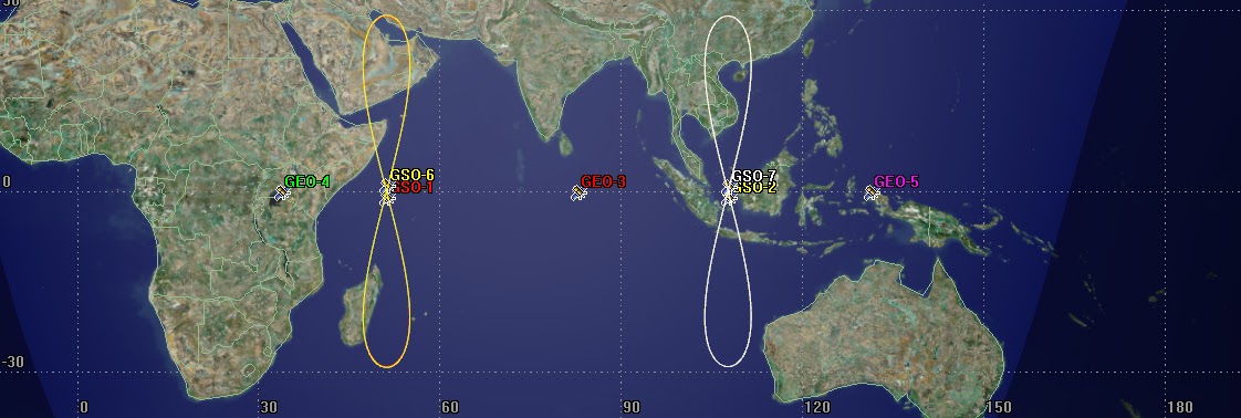
Fig 3 "Satellite Crowding" over
the equator (when set apart by 180o)
We can notice
that the geosynchronous satellites (titled GSO-#) are “crowded” near the
equator and the northern/southern regions of the target are does not have even
one satellite looking over them. From the “Possibility” standpoint, satellites,
while at the equator can look or can be made to look at the northern/southern
ends of the target area but from the “Feasibility” standpoint, it would call
for a frequently changing heavily demanding attitude maneuvers, complicating
station-keeping efforts. Moreover a straight view from the point above is more
precise than the inclined view from a far off distance, meaning, the
error-correction challenges would be greater in magnitude and intensity. Spatial
configuration of constellation does impact the accuracy of navigation and in
space-terms, it is often denoted by the Position Dilution of Precision Factor
(PDOP factor). It is true that error-correction to great extents is possible in
today’s world, but that would make the cost of positioning service higher than
the estimated amount, leading to unavailability and inaccessibility due to
monetary and administrative reasons, in whichever order they may impact.
I personally
feel, with the offset-positioning of geosynchronous satellites, the IRNSS would
have a constant view of its target region with a minimized attitude correction
executed on the GSS’s in a cyclical fashion. I always prioritize “comfortable
station-keeping” over anything else when it comes to preserving primary mission
objectives. The Fig.4 given below shows how I expect the IRNSS satellites to be
placed, if the idea is to have at least one satellite look over both the
northern and southern regions respectively:

Fig 4 Geosynchronous satellites positioned
for coverage and continuous visibility (north/south of target area)
It has to be
noted that, for two satellites to be above and below the equator at the same
time looking over India, the two geosynchronous orbits need to be inclined to
the equator such that one of them should be indicated with a negative angle for
inclination (for the sake of symmetry) such as 29o and -29o.
Now negative inclination is just a mathematical indication of the downward
inclination the orbit might have with respect to the equator. In real terms the
inclinations of the orbits may be 29o and 151o. The
launch costs may increase but if the cost of positioning service at the
error-correction/ground-based processing stage is reduced with expensive launches
(lift-off and delta-V burns), then I would consider that a valuable and sensible
investment as the whole purpose of the program is to create an effective
positioning service to be used by the military and civilian population of India
and possibly by those in the surrounding regions. Also largely varying
elevation and azimuth angles of satellites would mandate a strongly regulated
ground-based tracking system that has the flexibility and economic frugality to
accommodate the data coming in from far away directions at the same time. I
would suggest deploying separate ground stations dedicated for the IRNSS so as
to avoid over-use of available resources and also keep the positioning service
devoid of complications that may arise out of sharing transceiver resources.
Anomalies Noticed So Far
I am not really
sure about this but from what I know the official releases have claimed that
IRNSS-1A has been launched into an inclined geosynchronous orbit with an
inclination of 29o. I have been using publicly available internet
resources to track IRNSS-1A and the data that I have collected do not
corroborate the officially released data.
I downloaded the
TLE data of IRNSS-1A, (from www.space-track.org) some of which is given below:
TLE downloaded
sometime around the end of July, 2013:
1 39199U 13034A 13218.60084382 .00000094 00000-0 10000-3 0 244
2 39199 027.0423 140.5285 0019429 182.2365 263.8787 01.00275460 565
TLE Downloaded around
middle of Aug, 2013:
1 39199U 13034A 13227.33681052 .00000000
00000-0 10000-3 0 327
2 39199 027.0503 140.3669 0019595 184.2844 175.6837 01.00274917 647
2 39199 027.0503 140.3669 0019595 184.2844 175.6837 01.00274917 647
TLE Downloaded
on 29th, Aug, 2013:
1 39199U 13034A 13240.13145032 .00000088
00000-0 10000-3 0 363
2 39199 027.0586 140.1274 0019230 182.8373 115.8814 01.00269935 774
2 39199 027.0586 140.1274 0019230 182.8373 115.8814 01.00269935 774
For those who
are new to the concept of TLE data, please click here to
learn more about what this data represents.
The 9th
to 16th characters in the second line of Two Line Element set,
indicate the inclination of the satellite’s orbit and in the case of IRNSS-1A,
whose TLE data is given above, shows that as of 29th August, 2013,
IRNSS-1A is in an orbit that is inclined at 27o with the equator. This
is 2 degrees lesser than that is officially released (29o). A
difference of 2 degrees in inclination seems mathematically small but in
space-terms, missing the target orbit by 2 degrees is colossal mission failure
that would impact the entire constellation configuration and operational
effectiveness of the IRNSS.
Assuming there was
no typographical error/understanding error in the official releases, IRNSS-1A’s
launch and orbital maneuvers might have faced anomalies that have resulted in
ineffective transfer burns that resulted in the satellite’s failure to find its
berth in the target orbit. It is usual for satellites to take weeks before
finding their berth in their target orbit owing to various factors, most of
which might be natural and totally random. That is the reason I took multiple
readings of the TLE data of IRNSS-1A, just to make sure, I don’t catch it at
the wrong time. But, two days from today, by the end of August, 2013, it would
be over 60 days from the initial lift-off for IRNSS-1A. For one thing, it is
yet to get into the previously declared 29o inclined orbit and for
the other, it has been officially declared that IRNSS-1A’s launch is successful
and that it has been placed in its target orbit with a status of good-functioning.
I do not understand the contradiction of facts from complimentary credible
sources. The funniest part is where the official document released contradicts
itself by mentioning both the 29 and 27 degree inclinations, one in an image
and the other in a specs column of the same document. Seriously, there is no
such thing as security reasons or confidentiality that is required to indicate
two different inclination angles for a satellite. The satellite industry is
very visible in public domain and the whole world can learn about any satellite
that is flying around the earth.
Opportunities provided by IRNSS
A whole world of
opportunities would be open to India with the IRNSS including, elementary
terrestrial, aerial and marine navigation that may be used by the defense
establishments. The civil applications mean more than anything in my view. With
the help of a dedicated navigational system in place, the civilian population
will get a viable access to what is popularly called as vehicle tracking and
fleet management. The Indian fishermen along the coast of Tamilnadu and Kerala,
who are currently left vulnerable to firing and arrests by the Sri Lankan Coast
Guard for crossing maritime border will get an opportunity to track their
location with respect to the border that they do not want to cross. Most
importantly, they will get a concrete scientific method to prove their
innocence with regards to their not crossing the borders. The implementation
however requires the administration to issue the tracking devices that may be
installed in all the fishing boats. The tracking data will be recorded on a
timely basis and the administration will have an eye on all the fishermen who
go out into the waters. Anyone who is nearing the borders can we warned about
it and the data can be shared with neighboring countries so that both countries
would know whose boat is located how far from each other’s maritime border.
This way any case of arrests/firing may be dealt with the analysis of this
tracking information recorded and be used to resolve conflicts. This will
empower the fishermen to scientifically prove in cases where they encountered
firing/arrests, without crossing the maritime borders. The administrations too
cannot claim trespassing without any tracking data that may suggest fishing
boats have crossed the maritime borders. One press of a button and the
shore-station would get the distress call from the fisherman who is suspecting
an attack or arrest from neighboring coast guard ships. One bright glow and loud
alarm from the tracking device on the fishing boat can alert the fisherman if
he is about to cross the maritime border. All the legitimate boats will have a
designated tracking device and therefore identifying pirate vessels from
harmless fishing vessels would become a reality. The solution to such sea-based
border issues however require the strict implementation of such tracking
information in the marine industries, especially fishing. With IRNSS in action,
the administration need not view the cost of renting out other navigational
systems as an administrative burden.
The average
Indian would have access to finding routes within India and traveling by self
would become more safe and comfortable. The defense establishments would have
accurate tracking systems to help them during military operations along the
disputed borders, more importantly without having to depend on international
administrations.
Challenges for IRNSS
The
configuration of IRNSS calls for reliable satellites since, this constellation
operates on a minimum number of satellites from the navigational standpoint.
For an accurate positioning on earth, at least 4 satellites are required. With
3 geostationary and 4 geosynchronous, the constellation cannot afford to have
any satellite system/sub-system failure. Losing one satellite means losing
precise tracking in one region of the IRNSS target area. The IRNSS
constellation, from the systems engineering point of view, is yet to add the
element of redundancy for reliability. This may be due to cost restrictions but
having an expensive system so vulnerable actually makes the investment very
risky. In future, I would like to see more satellites operating over regions
already covered by these 7 satellites, such that, if one of the satellites
fails, the system’s functionality does not get compromised. The back-up
satellites are an additional cost but their presence means prolonged “system-survivability”
and in case of no failures, added positioning accuracy. The additional
satellites may be used for military operations unless there is a need for a
civilian deployment in case of a failure.
One more area to
look into while considering add-on satellites is constellation optimization methods that can help estimate and
determine satellite positions in existing and new orbits so as to enable the
reliability and extended lifetime of mission objectives.
The STK
simulations show that the IRNSS-1A goes through a one-hour eclipse almost every
day, with the eclipse timing ranging from 0.3 to 1.3 hours. The average is around
1 hour. Now the satellite is powered with a 90 ampere-hour lithium battery and
solar panels that have a capacity of 1.6 kW. Regular discharge and recharging
of batteries do impact the battery lifetimes and the satellite should not be
rendered useless because of a failed battery given that apart from the
payload, other sub-systems of the satellite depend on the battery power too.
The chances may be rare but when electrically operated attitude-control
maneuvers and payload activity clash during an eclipse time, the satellite goes
into a peak demand state and a repetitive exposure to such peak-demand
situations may impact the battery negatively. The subsystem with the shortest
life-span would be the life-span of the entire satellite and it definitely
should not be the power system i.e., the solar panels and battery-pack.
What Else to Look For
Well, the first
thing to catch my attention is the cost and reliability of the hand-held
equipment that can be used as the ground-based tracking devices. This is mainly
because, it is a popular trend here in India for the government issue
electronics to be outdated, notoriously unreliable and clumsy in appearance and
handling comfort, mostly because the government issue is either free or for a
low fee. I am not entirely sure but based on the fact that the data structure
of the satellite transmissions from the IRNSS satellites are very similar to
that of other global navigation systems, I am inclined to believe that the
currently available commercial GPS units might be able to receive IRNSS signals
and provide directions. So consumers might have an option of using their GPS
units to receive IRNSS signals for their tracking needs.
I had a great
time looking into the details of IRNSS and its first satellite IRNSS-1A. While
preparing for this post, I got an opportunity to work with Systems Took Kit
(STK), previously known as Satellite Tool Kit (about 5 years back). Thanks to AGI Systems for providing STK and www.space-track.org for providing the TLE data & helping me via Space-Track.Org's facebook fanpage. I sincerely
hope IRNSS becomes a success in terms of real-world applications in India,
helping the military and civilian population alike. Thanks to whoever pitched
the idea of Indian Regional Navigational Satellite System. I am sure there is
so much to this system than what we have explored so far and I would look for
more to learn about it as the system is realized in due course.
On a very different note [a shameless plug], if you are interested in unique tamil short films, feel free to visit https://www.summamovies.com/. I couldn't tolerate the mass masala entertainers anymore and decided I will do my best to produce content with substance. I have a long a way to go as a producer and a start-up founder, but I am glad our journey has begun. I look forward to your support. Each film on our site costs INR 15. Thanks!!!
On a very different note [a shameless plug], if you are interested in unique tamil short films, feel free to visit https://www.summamovies.com/. I couldn't tolerate the mass masala entertainers anymore and decided I will do my best to produce content with substance. I have a long a way to go as a producer and a start-up founder, but I am glad our journey has begun. I look forward to your support. Each film on our site costs INR 15. Thanks!!!
References:
S.No.
|
Description
|
1
|
Dr. S.V. Kibe. GAGAN and IRNSS.
Presentation to ICG-3, Dec, 2008. India.
|
2
|
Bo J. Naasz, Kevin Berry, Kenneth Schatten. Orbit Decay Prediction Sensitivity to Solar Flux Variations.
Advances in Astronautical Sciences, AAS 07-264, 2007. USA.
|
3
|
Panos Papadimitratos, Aleksandar Jovonovik. GNSS-Based Positioning: Attacks and Countermeasures. Ecole
Polytechnique Federale Lausanne. IEEE MILCOM, Nov, 2008.USA.
|
4
|
Hai-Fu Ji, Li-Hua Ma, Guo-Xiang Ai, Hu-Li Shi. The Principle of Navigation Constellation Composed of SIGSO
Communication Satellites. Research in Astronomy and Astrophysics, Vol.0
(200X), Nov, 2012. China.
|
5
|
Ahmed Kamel, Donald Ekman, Richard Tibbitts. East-West Stationkeeping Requirements of Nearly Synchronous
Satellites Due to Earth’s Triaxiality and Luni-Solar Effects. Celestial
Mechanics, Volume 8, Issue 1, pp.129-148, Aug, 1973.
|
6
|
Pierre Jannierre, Jean-Luc Palmade.
Improving Availability When Designing a Navigation Satellite Constellation.
International Cooperation in Satellite Communications, Proceedings of the
AIAA/ESA Workshop held 27-29 March, 1995. The Netherlands.
|
7
|
T.J. Goblick Jr. Navigation with
High-Altitude Satellites: A Study of Ranging Errors. Technical Note,
1966-46, Aug, 1966. USA.
|
8
|
Dr. Li Qiao. SAR Formation
Flying: Annexure 7: Orbit Modelling and Analysis, Simulated Mission Planning.
Garada, Australian Centre for Space Engineering Research, Jun, 2013.
Australia.
|
9
|
ISRO. ILRS SLR Mission Support
request Form. Jan, 2012. USA.
|
10
|
Chris Hall. Introduction to
Attitude Dynamics and Control. Aerospace and ocean Engineering, Virginia
Tech. USA.
|
11
|
Unknown. Indian Regional
Navigation Satellite System (IRNSS). Jan-Jun, 2012, Space India. India.
|
12
|
A. Milani et al. Orbit 14: The
Propagator. Page 1-20. Italy.
|
13
|
ISRO. PSLV-C22/IRNSS-1A,
ISRO. India.
|
14
|
Rakesh Panwar. IPS Radio and
Space Weather Services:Satellite Orbital Decay Calculations. Bureau of
Meteorology, Australia.
|
15
|
David Wright, Laura Grego, Lisbeth Gronlund. Section 5: Types of Orbits or Why Satellites are Where They Are. The
Physics of Space Security. USA
|
16
|
Research Concepts, Inc. Research Concepts Inclined Orbit Tracking Satellite
Antenna Controllers. USA.
|
17
|
Lihua Ma. The Benefits of Inclined-Orbit Operations for Geostationary
Orbit Communication Satellites. Artificial Satellites, Vol. 46, No. 1 – 2011. Poland.
|
18
|
Internet Resources:
|
